
I am going. Now how do I get there?
Click Here to view Printable Trail map
For GPS and Mapping Systems try entering Supai Trail, Supai, AZ, 86435. Google Maps currently uses this to find the Hill Top Trail Head Parking area at the end of IR# 18. Google also shows the trail down to Supai if you zoom in far enough. Click this Link to view the Trail Head parking lot in Google Maps
If your app or map does not work with the above given address. Map to Kingman, Peach Springs, AZ, or Seligman, AZ. Then use the below stick map to calculate the additional distance.
The 65 miles or so of IR#18 will most people about 1 hr and 10 minutes to drive.
Click to Print a Paper Map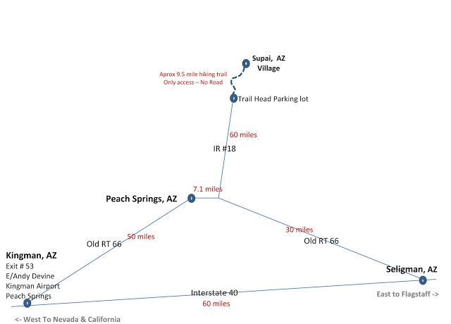
There is no true address for the Hill Top Trail Head Parking area. But the Parking Area is at the dead end of Indian Road #18 or IR 18. Also known as IR# 18.
IR# 18 goes north off old Rt 66. This intersection is a few miles east of Peach Springs, Arizona. From this intersection you need to travel north on IR# 18 for a little over 60 miles. This is a lonely stretch of desolate road.
It is highly recommend you don’t travel this section in the dark. Make sure you have a full tank of gas since you have to do a round trip to Peach Springs or Seligman, AZ.
We are talking a round trip from Peach Springs of about 140 miles.
A round trip from Seligman of about 180 miles.
If coming from the east through Seligman there is gas on RT 66 east of the IR 18 intersection at mile marker 115 (Grand Canyon Cavern area) which would be about 140 miles round trip from there. If traveling that direction it is suggested you top off your gas here.
Can I camp at the trail head parking area? See CAMPING HILLTOP PARKING – TRAIL HEAD AREA.
Do NOT take non-blacktop paved roads in the area
A word of very serious caution, as in Life & Death. Do not attempt back road short cuts in this area. Especially a route that comes up on some GPS between the Supai Trail Head parking lot, and over to the South Rim Grand Canyon NP area. Don’t even attempt it with 4 wheel drive. Especially Willaha County Road if it comes up on your GPS.
There is a true life TV special on a girl that got stranded in that area. It could have been on Willaha County Road even. She claims GPS routed her that way. She ran out of gas and was stranded for days.
There are no people or services and these back roads are dirt and unmarked. All roads are dirt or rocky and soon go down to two wheel ruts. They wander off into the desert and disappear. No signage, etc. Often the way is on slick rock with no sense of a road. It is even difficult to figure out the way you came in even if you realize you made a terrible error in judgement. Any rain makes them instantly more treacherous. This area is not even recommended with 4 wheel drive.
This is the kind of area that you could easily get lost, or have minor vehicle trouble, that could prove to be fatal.
If you aren’t on a paved road you are lost and going the wrong way!!!
If you are traveling from the South Rim Grand Canyon NP area, plan on the route below. It is 192 miles and about a 4 hr drive: All on pavement and marked with signs. But you will arrive, and arrive alive, and make the trip.
If you are traveling from the South Rim Grand Canyon NP, to the Supai Trail head be sure to take Rt 64 to Williams, I-40 to Seligman, Rt 66 to the intersection of IR #18, then on to the Supia Trail Head. Reverse that if your trip has you going to the South Rim after visiting Supai. There are no safe short cuts.
Even IR #18 is not the place you want to be traveling in the dark. It is paved. but…..mainly because of large wildlife and dark “open range cattle”. While it would be difficult to get lost on IR #18, it is a desolate road with absolutely no services or even homes along the way for about 60 miles. Other back roads in that area shouldn’t even be on the map to fake out non-locals that don’t know any better. Stick to RT 66 & IR #18.
Make sure you gas up in Seligman (coming thru from the east), or Peach Spings/Kingman (coming thru from the west) because you need to make it to the trail head parking, then all the way back to Peach Springs or Seligman for the nearest gas on your way out. This is in excess of 140 miles either way.
Practice normal security precautions with valuables left behind in your parked vehicle. Locked and things out of sight preferably locked in the trunk.
No one I know personally, myself included, have never experience such an incident. I even parked way up the hill at a gravel packing area once, due to how busy the parking area was. I had my van and a RV trailer parked up in the dumpster area. (If you happen to get stuck up there be sure to not block garbage truck access to dumpsters, or any personal cars parked there.)
The point being is, even though it is isolated up there, I have never experienced a problem.
But from time to time people report break-ins occur. I have yet to get break-in info first hand from someone. It’s always “I have heard”, or “it happened to someone else”. So just a word to the wise.
![]()